Physical Boundary Conditions for Tidal River Management
Research steps
Step 1 Delta level: Analysis and simulation of sediment dynamics
At the delta level, we analyze the current spatiotemporal river flow characteristics of southwestern Bangladesh to find locations with maximum feasible amount of sediments that can be delivered by a river channel. A general characterization of upstream-downstream changes in water levels, salinity and sediment concentrations will be made. We explore how these patterns identify potentially suitable locations for controlled inlets to the polders.
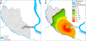
Example of modeled sedimentation (quantity, spread) at the beel level based on inlet location
Step 2 Polder level: Analysis and simulation of Building with Nature scenarios
We analyze how controlled flooding and sediment accretion can be optimally used for individual polders (i) to raise its surface level and (ii) to enable human activities. Simulations of water flow and sediment deposition will be performed with Delft3D. Sensitivity analysis on the polder lay-outs will be carried out by varying inlet and outlet dimensions together with flow pathways and velocities through the polder. Plant incubation experiments will be run locally to test the fertility of the soil and fresh sediment and ways to enhance it by e.g. drainage.
Step 3 Feedbacks: Identifying polder-river channel interactions and impacts at delta scale
We analyze how controlled flooding and polder accretion in one part of the delta affect tidal river flow patterns and erosion/sedimentation of suspended matter elsewhere. We will simulate different scenarios of ‘rotation schemes’ between polders for temporary re-opening, depending on quantity, location and expected length of required accretion cycles.
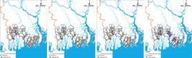
Examples of TRM rotation schemes at the delta level
Step 4 Living Polders: Optimizing and upscaling delta level rotation schemes of polder raising
Polders at different geographical locations will have different optimal rotation schemes as type of sediment, soil fertility, risk of salinization and accretion rates are different. This step determines planning schemes to maximize cultivation potential while minimizing risks for accidental flooding, erosion and salinization.
People
-

- Md Feroz Islam
-

- Stefan Dekker
-

- Jasper Griffioen
-

- Atikul Islam
-

- Md. Shah Alam Khan
-

- Hans Middelkoop
-
- Paul Schot
Scientific publication
- Islam, M. F., Middelkoop, H., Schot, P. P., Dekker, S. C., & Griffioen, J. (2021). Spatial and seasonal variability of sediment accumulation potential through controlled flooding of the beels located in the polders of the Ganges-Brahmaputra-Meghna delta of Southwest Bangladesh. Hydrological Processes, 35(4), [e14119]. https://doi.org/10.1002/hyp.14119
- Islam, M. F., Middelkoop, H., Schot, P. P., Dekker, S. C., & Griffioen, J. (2020). Enhancing effectiveness of tidal river management in southwest Bangladesh polders by improving sedimentation and shortening inundation time. Journal of Hydrology, 590, [125228]. https://doi.org/10.1016/j.jhydrol.2020.125228
- Islam, M. F., Bhattacharya, B., & Popescu, I. (2019). Flood risk assessment due to cyclone-induced dike breaching in coastal areas of Bangladesh. Natural Hazards and Earth System Sciences, 19(2), 353-368. https://doi.org/10.5194/nhess-19-353-2019